Southwest Michigan Bikeway – Resources
Bike Friendly Kalamazoo’s volunteer participants began work on mapping one of the largest transportation and destination-oriented bikeways in the nation in 2012. Over time the network has been named and is being signed as the Southwest Michigan Bikeway (SWMB), little by little. As illustrated in the map below, the SWMB includes approximately 380 centerline miles of bike routes that connect all the named municipalities and institutions of higher learning within the Kalamazoo Area Transportation Study’s metropolitan planning organization. Click here for list of destinations connected in the plan.
This page is a step toward assembling the many resources that describe the SWMB, as Bike Friendly Kalamazoo’s contribution to the greater community and building on the work of the Kalamazoo Region Bike Route Committee. To reduce the time it takes to update links on our web site, over time we will be moving items from other pages on our website that duplicate this information onto this page. With the November 17, 2021 adoption of the 2050 KATS Metropolitan Plan, items on this page that are slightly outdated are scheduled for revision as time permits.
The Kalamazoo Region Bike Route Committee (KRBRC) has been meeting ever since adoption of the routes in the Southwest Michigan Bikeway to facilitate its implementation, in a collaborative and collegial manner.
KRBRC Meeting Notes 260421 (This Kalamazoo Region Bike Route Committee Quarterly Meeting is of interest because it focused on a hypothetical example of how numbered guide signs that are now incorporated in the most recent edition of Michigan’s Manual of Uniform Traffic Control Devices (MMUTCD), exploring an initial set of planning principles and pros and cons of use.)
KRBRC Meeting Notes 260113 (This Kalamazoo Region Bike Route Committee Quarterly Meeting is of interest because it focused on exploring bicycle Guide signs in the Federal Manual of Uniform Traffic Control Devices, most of which may be incorporated in the upcoming edition of Michigan’s Manual of Uniform Traffic Control Devices, or MMUTCD)
KRBRC Meeting Notes 250729 (This Kalamazoo Region Bike Route Committee Quarterly Meeting is of interest because it focused on a goal of planning connections within the City of Kalamazoo, given its significant street redesign since the original connections were planned)
KRBRC Meeting Notes 250422 (This Kalamazoo Region Bike Route Committee Quarterly Meeting is of interest because it focused on a goal of planning connections within the City of Kalamazoo, given its significant street redesign since the original connections were planned)
KRBRC Meeting Notes 250128 (This Kalamazoo Region Bike Route Committee Quarterly Meeting is of interest because it focused on a goal of planning connections among Municipalities: immediately adjacent to but outside the Kalamazoo Area Transportation Study (KATS) Metropolitan Planning Organization (MPO), and, within/proximate vicinity of the seven counties that define MDOT’s Southwest Region)
KRBRC Meeting Notes 241021 (This Kalamazoo Region Bike Route Committee Quarterly Meeting is of interest because it demonstrates the process underway to make use of wayfinding signs on the Southwest Michigan Bikeway as a community development effort; reducing wayfinding confusion may provide a potential public safety enhancement; this meeting focused on D1-series destination-distance-direction signs for Oshtemo Township)
KRBRC Meeting Notes 240716 (This Kalamazoo Region Bike Route Committee Quarterly Meeting is of interest because it demonstrates the process underway to make use of wayfinding signs on the Southwest Michigan Bikeway as a community development effort; reducing wayfinding confusion may provide a potential public safety enhancement; this meeting returned to focus on the D1-series destination-distance-direction signs for the City of Portage)
KRBRC Meeting Notes 240423 (This Kalamazoo Region Bike Route Committee Quarterly Meeting is of interest because it demonstrates the process underway to make use of wayfinding signs on the Southwest Michigan Bikeway as a community development effort; reducing wayfinding confusion may provide a potential public safety enhancement; this meeting was the second in a row to focus on D1-series destination-distance-direction signs for WMU’s Main and Parkview Campuses)
KRBRC Meeting Notes 240123 (This Kalamazoo Region Bike Route Committee Quarterly Meeting is of interest because it demonstrates the process underway to make use of wayfinding signs on the Southwest Michigan Bikeway as a community development effort; reducing wayfinding confusion may provide a potential public safety enhancement; this meeting focused on D1-series destination-distance-direction signs for WMU’s Main and Parkview Campuses)
KRBRC Meeting Notes 231024 (This Kalamazoo Region Bike Route Committee Quarterly Meeting is of interest because it demonstrates the process underway to make use of wayfinding signs on the Southwest Michigan Bikeway as a community development effort; reducing wayfinding confusion may provide a potential public safety enhancement; this meeting focused on D1-series destination-distance-direction signs for larger municipal destinations with many potential destinations within their borders)
KRBRC Meeting Notes 230724 (This Kalamazoo Region Bike Route Committee Quarterly Meeting is of interest because it demonstrates the process underway to make use of wayfinding signs on the Southwest Michigan Bikeway as a community development effort; reducing wayfinding confusion may provide a potential public safety enhancement; this meeting focused on D1-series destination-distance-direction signs for Oshtemo Township)
KRBRC Meeting Notes 230418 (This Kalamazoo Region Bike Route Committee Quarterly Meeting is of interest because it demonstrates the process underway to make use of wayfinding signs on the Southwest Michigan Bikeway as a community development effort; reducing wayfinding confusion may provide a potential public safety enhancement; this meeting focused on D1-series destination-distance-direction signs for the City of Kalamazoo)
KRBRC Meeting Notes 230117 (This Kalamazoo Region Bike Route Committee Quarterly Meeting is of interest because it demonstrates the process underway to make use of wayfinding signs on the Southwest Michigan Bikeway as a community development effort; reducing wayfinding confusion may provide a potential public safety enhancement; this meeting focused on D1-series destination-distance-direction signs for the City of Portage)
About The Southwest Michigan Bikeway (one page overview)
Public Route Development Process (for developing the original route network between 2012 and the end of 2015; describes systematic and repeatable community engagement and participation)
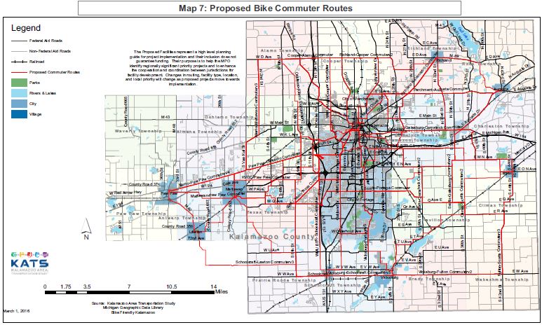
Southwest Michigan Bikeway Implementation Plan (Most recent draft version available from the Kalamazoo Region Bike Route Committee. Southwest Michigan Bikeway is another name for the regional route network being signed as such. Maps of the network were first proposed as “Map 7” or “Bike Commuter Routes” in the KATS 2045 Transportation Plan. The “Bike Commuter Route” nomenclature are now referred to as “Regional Bike Routes” in the more recently adopted KATS 2050 Metropolitan Transportation Plan.
Southwest Michigan Bikeway: Overview & Update (Powerpoint dated August 2, 2022)
Southwest Michigan Bikeway Sign Guidelines (Recommended by the Kalamazoo Region Bike Route Committee, January 29, 2018; Destination-Direction-Distance, the so-called D1-Series wayfinding have been supplemented in 2022 and may be found in the latest version of the Implementation Plan.)
Commuter Bike Route Network (Proposed) “Map 7” (final PDF map image of “Map 7” on page 148 of the KATS 2045 Metropolitan Transportation Plan. The route map has been adopted as “proposed.” Jurisdictions/agencies may use it as a guide to further implementation, knowing it has been vetted by KATS’ staff and its Technical and Policy Committees, after being developed by key community stakeholders in a process documented here.) “Map 7” is now being called the Southwest Michigan Bikeway; plans for its implementation are being prepared (see above).
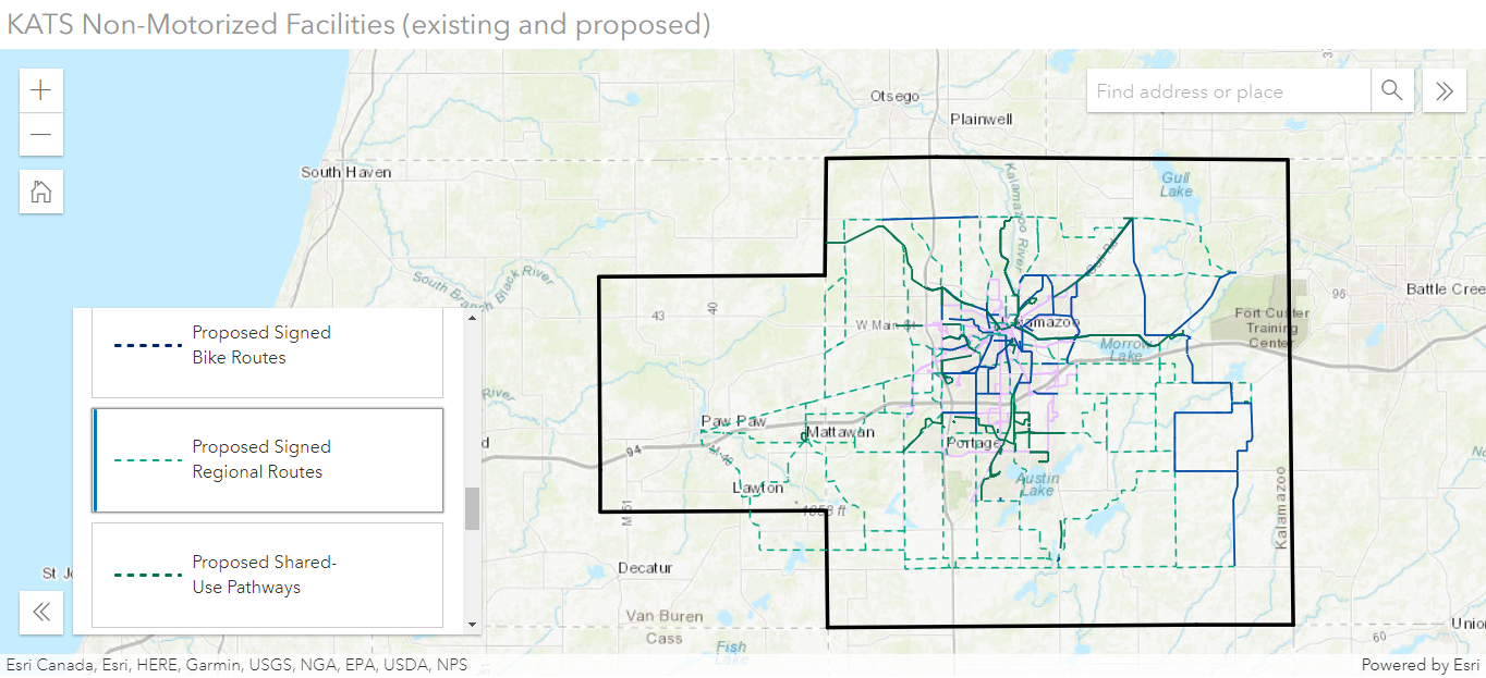
Regional Bike Route Network (existing and proposed) (The figure below is a static snapshot taken on July 5, 2022 of interactive map that was found on KATS website at that time but is no longer being made available without sign-on credentials). See KATS 2050 Metropolitan Transportation Plan, approved November 17, 2021. KATS intends to keep the interactive map non-motorized map as current as possible, possibly on a quarterly basis, in order to facilitate review by its committees and its incorporation in subsequent versions of their Metropolitan Transportation Plans.
Commuter Bike Route Network (Proposed): RWGPS Route List (Ride With GPS web site of final set of individual routes that make up “Map 7” as vetted and narrowed down from the catalog of hundreds of BFK Commuter Route alternatives. Routes can be downloaded for further analysis. Comments contain name of route designer and other useful information.)
D-1 Series Alternatives Worksheet (From Kalamazoo Region Bike Route Committee meeting held January 18, 2022. Illustrates various alternative D-1 series Destination-Direction-Distance plaques used to supplement primary sign. Pros and cons from meeting participants included.)
Regional Bike Routes Connecting Map 7 to Adjacent Municipalities (Ride With GPS web site. Routes can be downloaded for further analysis. Comments contain name of route designer and other useful information.)
Southwest Michigan Bikeway – PDF (static PDF version of routes adopted as “Map 7” proposed inter-community routing in the KATS 2045 Metropolitan Transportation Plan; Map 7 is now also being called the Southwest Michigan Bikeway by many local planners)
Southwest Michigan Bikeway – Google Maps (interactive Google Maps version of routes adopted as “Map 7” proposed inter-community routing in the KATS 2045 Metropolitan Transportation Plan; many useful features: clicking on a route highlights the route and pulls up the route name; routes can be selected from a route list; more)
Southwest Michigan Bikeway (Proposed): RWGPS Route List (Ride With GPS web site of individual routes that KATS used to make up the Southwest Michgan Bikeway – aka, KATS Map 7). Hundreds of BFK Commuter Route alternatives were reviewed, vetted, and narrowed down to make up this final list. Routes can be downloaded for further analysis. Comments contain name of route designer and other useful information.)
Support for Southwest Michigan Bikeway
Letters of Support Letters of support for signing the Southwest Michigan Bikeway using the M1-8a bike route sign and associated destination/direction/distance and turn arrow signs recommended by the Kalamazoo Region Bike Route Committee as received from the: City of Kalamazoo, Village of Paw Paw, Village of Vicksburg, City of Portage, Discover Kalamazoo, the Kalamazoo Bicycle Club, Trikats, Paul Runnels, Ed Sackley, Jennifer Johnson, Open Roads Bike Program, the Chain Gang Bicycle Club and Marc Irwin.
Charter Township of Oshtemo Resolution of Support Kalamazoo Regional Bike Route Committee Sign Design for the Southwest Michigan Bikeway Adopted September 9, 2018. The Southwest Michigan Bikeway is also known as KATS “Map 7.”
City of Portage Resolution to Promote Bicycle Safety adopted November 15, 2016 supporting and encouraging implementation of KATS “Map 7” Commuter Bike Routes, in addition to taking other safety and bike friendly measures.
Comstock Township Resolution in Support of Non-Motorized Plan Adopted April 3, 2017. Resolution to incorporate the Non-Motorized Element of the KATS 2045 Metropolitan Transportation Plan into local non-motorized plans. The resolution encourages other jurisdiction within the KATS MPO to do likewise.
Cooper Township Resolution in Support of Non-Motorized Element Adopted July 10, 2017. Resolution to incorporate the Non-Motorized Element of the KATS 2045 Metropolitan Transportation Plan into local non-motorized plans. The resolution encourages other jurisdiction within the KATS MPO to do likewise.
Kalamazoo County Resolution Supporting Non-Motorized Plan Policy supporting and encouraging development and implementation of KATS Non-Motorized Element, among other measures (agenda item BB, page 10); adopted December 20, 2016.
Kalamazoo County Resolution Supporting Uniform Bike Route Signage Policy supporting the recommendations of the Kalamazoo Region Bike Route Committee regarding Southwest Michigan Bikeway signage and encouraging road agencies to do likewise (agenda Item 7, pages 10-11); adopted June 2, 2020.
RCKC’s 2045 Proposed Commuter Routes Southwest Michigan Bikeway RCKC Signing Implementation Plan 2018 – 180926 Road Commission of Kalamazoo County Plan for signing the Southwest Michigan Bikeway based on “Map 7” in the KATS 2045 Metropolitan Transportation Plan
RCKC’s SWMB Signing Implementation Plan Progress Report 200915 Road Commission of Kalamazoo County progress report on signing the Southwest Michigan Bikeway based on “Map 7” in the KATS 2045 Metropolitan Transportation Plan